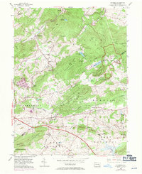
1954 Map of Elverson
USGS Topo · Published 1970About this map
Hopewell Village National Historic Site anchors the northeastern landscape of this survey, preserving a fragment of Pennsylvania's early industrial heritage near Hopewell Lake. The terrain is defined by the sharp contrast between the wooded heights of Long Mtn and Welsh Mountain and the developed corridors of the Reading railroad and the Pennsylvania Turnpike. Small agricultural and residential clusters like Geigertown, Joanna, and Elverson are connected by a network of rural roads and the long-distance Horseshoe Trail. Local spiritual and community life is marked by numerous country landmarks, including St Pauls Ch, Bethesda Ch, and Hause Sch. The map also captures the transition of older rail stations, such as Scarlets Mill (White Bear Sta), as the region's transportation shifted toward the modern toll road system crossing through Caernarvon and West Nantmeal townships.
Find a feature on this map
57 named features on this map. Tap any name to fly to it.
Don’t see what you’re looking for? This feature index may not catch every label — zoom into the map to look around manually.
Map Details
Editions of this 1954 Elverson Map
This is the sole edition of this map. No revisions or reprints were ever made.
Other maps of this area

1894 · Reading
USGS Topo · 1:62,500

1902 · Boyertown
USGS Topo · 1:62,500

1905 · Honey Brook
USGS Topo · 1:62,500

1906 · Phoenixville
USGS Topo · 1:62,500

1907 · Honeybrook
USGS Topo · 1:62,500

1913 · Reading
USGS Topo · 1:62,500

1915 · Reading
USGS Topo · 1:62,500

1941 · Honeybrook
USGS Topo · 1:62,500
1943 · Boyertown
USGS Topo · 1:31,680
1943 · Phoenixville
USGS Topo · 1:62,500
Featured Places
- Warwick Township, PA
- East Nantmeal Township, PA
- Elverson, PA
- Union Township, PA
- Scarlets Mill, Robeson Township