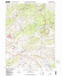
1997 Map of Elverson
USGS Topo · Published 1998About this map
Hopewell Village National Historic Site anchors the northeastern landscape of this survey, preserving the legacy of the region's early American iron industry. The terrain is defined by the wooded slopes of Long Mtn and Williams Hill, where the Horseshoe Trail and Lenape Trail navigate the protected lands of French Creek State Park. These high points drop down into valleys carved by French Creek and Hay Creek, where historic hamlets like Geigertown and Scarlets Mill (White Bear Sta) reveal long-standing settlement patterns.
Find a feature on this map
64 named features on this map. Tap any name to fly to it.
Don’t see what you’re looking for? This feature index may not catch every label — zoom into the map to look around manually.
Map Details
Editions of this 1997 Elverson Map
This is the sole edition of this map. No revisions or reprints were ever made.
Other maps of this area

1894 · Reading
USGS Topo · 1:62,500

1902 · Boyertown
USGS Topo · 1:62,500

1905 · Honey Brook
USGS Topo · 1:62,500

1906 · Phoenixville
USGS Topo · 1:62,500

1907 · Honeybrook
USGS Topo · 1:62,500

1913 · Reading
USGS Topo · 1:62,500

1915 · Reading
USGS Topo · 1:62,500

1941 · Honeybrook
USGS Topo · 1:62,500
1943 · Boyertown
USGS Topo · 1:31,680
1943 · Phoenixville
USGS Topo · 1:62,500
Featured Places
- Warwick Township, PA
- East Nantmeal Township, PA
- Elverson, PA
- Union Township, PA
- Scarlets Mill, Robeson Township