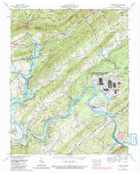
1968 Map of Elverton
USGS Topo · Published 1990About this map
Watts Bar Lake and the winding Clinch River dominate this landscape where ridges and valleys run in parallel southwest-to-northeast bands. The industrial presence of the U.S. Department of Energy (Oak Ridge Area) is prominent on the eastern side of the map, featuring a complex of facilities including a filtration plant, a meteorological tower, and a conveyor system near Pine Ridge. The rugged terrain of Walden Ridge and Blackoak Ridge is marked by extractive industries, evidenced by several strip mines and the L & N RR corridor following the Emory River. Numerous family-named burial grounds like Christmas Cem, Welcker Cem, and Suddath Cem are scattered throughout the valleys, providing a detailed record of the rural communities and early settlements such as Elverton and Blair that predated the mid-century industrial expansion.
Find a feature on this map
76 named features on this map. Tap any name to fly to it.
Don’t see what you’re looking for? This feature index may not catch every label — zoom into the map to look around manually.
Map Details
Editions of this 1968 Elverton Map
3 editions found
Other maps of this area

1887 · Kingston
USGS Topo · 1:125,000

1891 · Kingston
USGS Topo · 1:125,000

1893 · Briceville
USGS Topo · 1:125,000

1893 · Kingston
USGS Topo · 1:125,000

1895 · Wartburg
USGS Topo · 1:125,000

1895 · Loudon
USGS Topo · 1:125,000

1895 · Briceville
USGS Topo · 1:125,000

1896 · Wartburg
USGS Topo · 1:125,000

1896 · Briceville
USGS Topo · 1:125,000

1935 · Camp Austin
USGS Topo · 1:24,000