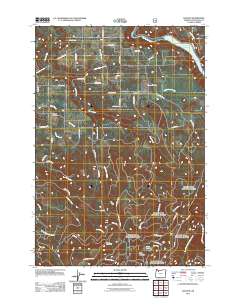
2011 Map of Elwood
USGS Topo · Published 2011About this map
The small communities of Elwood and Dodge anchor this 2011 survey of the Clackamas County hinterland. The landscape is defined by the complex drainage of the Clackamas River, which feeds the North Fork Reservoir in the northeast. This area maintains a distinct rural character, where the grid of agricultural roads like S Metzler Park Rd and S Springwater Rd gives way to the more irregular topography of the southern hills. Ge genealogists will find the Elwood Cemetery located just east of the main settlement, a quiet landmark amidst the tributaries of Dorn Creek and Clear Creek. To the south, the terrain rises significantly toward Green Mountain and Goat Mountain, where the network of forest roads and creeks like Jackson Creek and Little Clear Creek suggests a transition from farming into timber or protected wilderness lands. This map captures a moment of modern rural Oregon before suburban pressures altered the local road and waterway network.
Find a feature on this map
65 named features on this map. Tap any name to fly to it.
Don’t see what you’re looking for? This feature index may not catch every label — zoom into the map to look around manually.
Map Details
Editions of this 2011 Elwood Map
This is the sole edition of this map. No revisions or reprints were ever made.
Other maps of this area

1911 · Boring
USGS Topo · 1:48,000

1914 · Boring
USGS Topo · 1:62,500

1916 · Estacada
USGS Topo · 1:125,000

1940 · Boring
USGS Topo · 1:62,500

1948 · Vancouver
USGS Topo · 1:250,000

1950 · Vancouver
USGS Topo · 1:250,000

1950 · Vancouver
USGS Topo · 1:250,000
1954 · Redland
USGS Topo · 1:24,000
1954 · Estacada
USGS Topo · 1:24,000

1955 · Colton
USGS Topo · 1:62,500