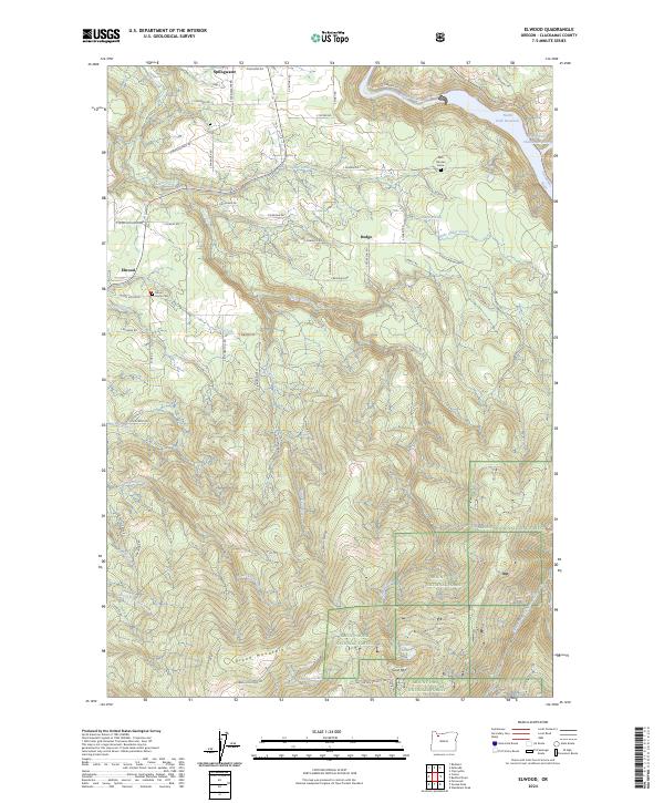
2024 Map of Elwood
USGS Topo · Published 2024About this map
Springwater, Elwood, and Dodge anchor this part of Clackamas County, where agricultural plateaus meet the timbered slopes of the Cascades. The landscape is defined by the deep drainage of Clear Creek and the Clackamas River, which flows into the North Fork Reservoir at the northeastern corner. This modern survey shows a transition from rural homesteads and family cemeteries, such as the Mount Home Cem, to the protected wilderness areas of the south. High points like Green Mountain and Goat Mtn rise above a dense network of creek-cut valleys, including Little Clear Creek and Jackson Creek. The presence of the Nick Clausen Grave near the Clackamas River provides a specific point of genealogical interest, while the southern reaches are dominated by the Mount Hood National Forest and the Clackamas Wilderness.
Find a feature on this map
65 named features on this map. Tap any name to fly to it.
Don’t see what you’re looking for? This feature index may not catch every label — zoom into the map to look around manually.
Map Details
Editions of this 2024 Elwood Map
This is the sole edition of this map. No revisions or reprints were ever made.
Other maps of this area

1911 · Boring
USGS Topo · 1:48,000

1914 · Boring
USGS Topo · 1:62,500

1916 · Estacada
USGS Topo · 1:125,000

1940 · Boring
USGS Topo · 1:62,500

1948 · Vancouver
USGS Topo · 1:250,000

1950 · Vancouver
USGS Topo · 1:250,000

1950 · Vancouver
USGS Topo · 1:250,000
1954 · Redland
USGS Topo · 1:24,000
1954 · Estacada
USGS Topo · 1:24,000

1955 · Colton
USGS Topo · 1:62,500