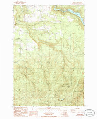
1986 Map of Elwood
USGS Topo · Published 1986About this map
Springwater and the surrounding rural communities of Elwood and Dodge define this mid-1980s landscape in Clackamas County. The terrain is deeply carved by the Clackamas River and its numerous tributaries, including Clear Creek and Little Cedar Creek. For local historians and genealogists, the placement of the Dorn Cem and another smaller Cem near the river provides valuable reference points for pioneer-era family research.
Find a feature on this map
27 named features on this map. Tap any name to fly to it.
Don’t see what you’re looking for? This feature index may not catch every label — zoom into the map to look around manually.
Map Details
Editions of this 1986 Elwood Map
This is the sole edition of this map. No revisions or reprints were ever made.
Other maps of this area

1911 · Boring
USGS Topo · 1:48,000

1914 · Boring
USGS Topo · 1:62,500

1916 · Estacada
USGS Topo · 1:125,000

1940 · Boring
USGS Topo · 1:62,500

1948 · Vancouver
USGS Topo · 1:250,000

1950 · Vancouver
USGS Topo · 1:250,000

1950 · Vancouver
USGS Topo · 1:250,000
1954 · Redland
USGS Topo · 1:24,000
1954 · Estacada
USGS Topo · 1:24,000

1955 · Colton
USGS Topo · 1:62,500