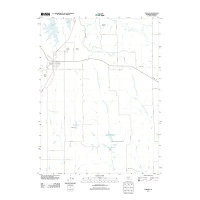
2011 Map of Elwood
USGS Topo · Published 2011About this map
Elwood serves as the central hub of this Gosper County landscape, where the town grid is anchored by the Elwood Post Office. The surrounding terrain is defined by a sophisticated water management system, featuring numerous engineered catchments such as Elwood Reservoir to the northwest and several private or municipal works including Bogle Reservoir, Whaley-Reynolds Reservoir Number 1, and Meyer Reservoir. These reservoirs are linked by a network of creeks and irrigation channels, including the West Branch Turkey Creek and Lateral E-65, illustrating the region's reliance on managed water for agricultural stability.
Find a feature on this map
38 named features on this map. Tap any name to fly to it.
Don’t see what you’re looking for? This feature index may not catch every label — zoom into the map to look around manually.
Map Details
Editions of this 2011 Elwood Map
This is the sole edition of this map. No revisions or reprints were ever made.
Other maps of this area

1896 · Lexington
USGS Topo · 1:125,000

1896 · Arapahoe
USGS Topo · 1:125,000

1898 · Arapahoe
USGS Topo · 1:125,000

1899 · Lexington
USGS Topo · 1:125,000

1955 · Grand Island
USGS Topo · 1:250,000

1957 · Grand Island
USGS Topo · 1:250,000

1958 · Grand Island
USGS Topo · 1:250,000

1962 · Bertrand NW
USGS Topo · 1:24,000
1971 · Arapahoe NE
USGS Topo · 1:24,000
1971 · Johnson Lake
USGS Topo · 1:24,000