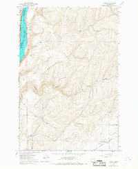
1966 Map of Elwood
USGS Topo · Published 1968About this map
Lake Sacajawea dominates the western edge of this mid-1960s landscape, serving as the border between Franklin and Walla Walla Counties. The terrain transitions from the river valley through the deeply carved Walker Canyon into the high, dry expanse of Eureka Flat. This area illustrates a mid-century agricultural economy tied closely to transportation, with numerous Storage Bins and a Grain Elevator situated along the rail lines and local roads.
Find a feature on this map
26 named features on this map. Tap any name to fly to it.
Don’t see what you’re looking for? This feature index may not catch every label — zoom into the map to look around manually.
Map Details
Editions of this 1966 Elwood Map
This is the sole edition of this map. No revisions or reprints were ever made.
Other maps of this area

1915 · Wallulah
USGS Topo · 1:96,000

1916 · Connell
USGS Topo · 1:125,000

1918 · Connell
USGS Topo · 1:125,000

1918 · Wallula
USGS Topo · 1:125,000

1919 · Walla Walla
USGS Topo · 1:125,000

1921 · Walla Walla
USGS Topo · 1:125,000

1948 · Ayer
USGS Topo · 1:62,500

1950 · Haas
USGS Topo · 1:62,500

1953 · Walla Walla
USGS Topo · 1:250,000

1958 · Walla Walla
USGS Topo · 1:250,000