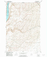
1991 Map of Elwood
USGS Topo · Published 1992About this map
Lake Sacajawea and the Snake River dominate the western edge of this landscape, marking the boundary between Franklin and Walla Walla Counties. The area is defined by the high, rolling expanse of Eureka Flat in the southeast and the deep incisions of Walker Canyon cutting through the center. This region represents the agricultural heart of the Walla Walla country, where the economy is driven by dryland farming and grain production. At the small settlement of Elwood, a prominent Grain Elevator stands as a central landmark for local transport and storage. The map documents an extensive network of rural routes, including Sheffler Road, Simmons Road, and Van Hollebeke Rd, which connect isolated Storage Bins and family-named landholdings across the plateau. This 1991 revision captures the infrastructure of Eastern Washington’s interior before more modern shifts in industrial agriculture.
Find a feature on this map
22 named features on this map. Tap any name to fly to it.
Don’t see what you’re looking for? This feature index may not catch every label — zoom into the map to look around manually.
Map Details
Editions of this 1991 Elwood Map
This is the sole edition of this map. No revisions or reprints were ever made.
Other maps of this area

1915 · Wallulah
USGS Topo · 1:96,000

1916 · Connell
USGS Topo · 1:125,000

1918 · Connell
USGS Topo · 1:125,000

1918 · Wallula
USGS Topo · 1:125,000

1919 · Walla Walla
USGS Topo · 1:125,000

1921 · Walla Walla
USGS Topo · 1:125,000

1948 · Ayer
USGS Topo · 1:62,500

1950 · Haas
USGS Topo · 1:62,500

1953 · Walla Walla
USGS Topo · 1:250,000

1958 · Walla Walla
USGS Topo · 1:250,000