
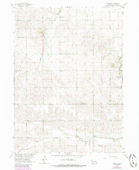
1963 Map of Emerick
USGS Topo · Published 1964About this map
Emerick lies at the heart of this Madison County landscape, where the agricultural sections of Grove and Highland townships meet. The map reveals a high density of rural social infrastructure from the early 1960s, specifically a remarkably preserved network of country schools that anchored these farming neighborhoods. One can trace the placement of the Deer Creek Sch and Mt Hope Sch in the north down to the Brookside Sch along the banks of Battle Creek.
Find a feature on this map
17 named features on this map. Tap any name to fly to it.
Don’t see what you’re looking for? This feature index may not catch every label — zoom into the map to look around manually.
Map Details
Editions of this 1963 Emerick Map
2 editions found
Other maps of this area

1955 · Sioux City
USGS Topo · 1:250,000

1955 · Fremont
USGS Topo · 1:250,000

1957 · Fremont
USGS Topo · 1:250,000

1958 · Sioux City
USGS Topo · 1:250,000

1958 · Fremont
USGS Topo · 1:250,000

1959 · Sioux City
USGS Topo · 1:250,000

1963 · Battle Creek
USGS Topo · 1:24,000

1963 · Pierce SE
USGS Topo · 1:24,000

1963 · Meadow Grove
USGS Topo · 1:24,000

1963 · Closter SE
USGS Topo · 1:24,000