
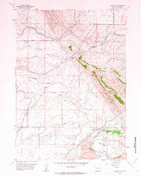
1950 Map of Emigrant Gap NE
USGS Topo · Published 1952About this map
Emigrant Gap Ridge dominates the southwestern corner of this 1950s terrain study in Natrona County, providing a significant high-ground landmark for the surrounding drainage system. The landscape is defined by its early water management infrastructure, including the Casper Canal, Johnson Canal, and the Bishop Lateral, which were critical for the development of the Missouri River Basin. These irrigation features wind through the draws, such as Tudor Draw, while the South Fork Casper Creek cuts through the northern sections. A notable technical installation, the Radio Range Station, sits centrally on the map, reflecting the mid-century integration of aviation navigation into the rural landscape. Historical transit is represented by Thirtythree Mile Road and remnants of the Sixmile Supply (Aban'd) ditch, showing the evolution of local resources and connectivity in this high plains environment.
Find a feature on this map
12 named features on this map. Tap any name to fly to it.
Don’t see what you’re looking for? This feature index may not catch every label — zoom into the map to look around manually.
Map Details
Editions of this 1950 Emigrant Gap NE Map
This is the sole edition of this map. No revisions or reprints were ever made.
Other maps of this area

1950 · Emigrant Gap
USGS Topo · 1:24,000

1950 · Goose Egg
USGS Topo · 1:24,000

1951 · Oil Mountain
USGS Topo · 1:24,000

1951 · Emigrant Gap NW
USGS Topo · 1:24,000

1952 · Bishop
USGS Topo · 1:24,000

1955 · Arminto
USGS Topo · 1:250,000

1955 · Casper
USGS Topo · 1:250,000

1958 · Casper
USGS Topo · 1:250,000

1958 · Arminto
USGS Topo · 1:250,000
1960 · Emigrant Gap
USGS Topo · 1:24,000