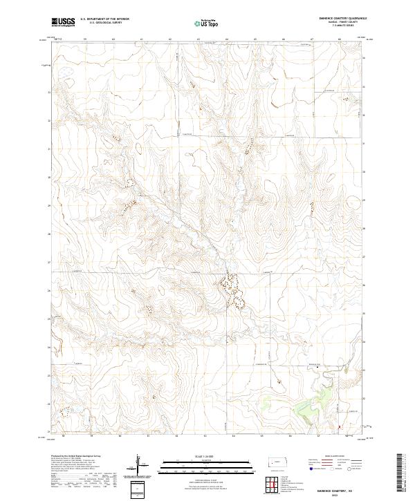
2022 Map of Eminence Cemetery
USGS Topo · Published 2022About this map
The Pawnee River meanders through the southern reaches of this Finney County landscape, defining the topography of this rural Kansas expanse. This area is characterized by a grid of section lines and gravel roads, including E Eminence Rd and N Hund Rd, which connect the isolated farmsteads and agricultural plots of the High Plains. Located along the road that shares its name, Eminence Cem serves as a primary point of interest for genealogists and local historians, marking a quiet point of community memory within the larger township structure of T22S R29W. The map documents the subtle drainage patterns feeding into the river valley, offering a precise look at the land use and property boundaries in this section of the state during the early twenty-first century.
Find a feature on this map
20 named features on this map. Tap any name to fly to it.
Don’t see what you’re looking for? This feature index may not catch every label — zoom into the map to look around manually.
Map Details
Editions of this 2022 Eminence Cemetery Map
This is the sole edition of this map. No revisions or reprints were ever made.
Other maps of this area

1955 · Scott City
USGS Topo · 1:250,000

1958 · Scott City
USGS Topo · 1:250,000

1974 · Ravanna
USGS Topo · 1:24,000
1974 · Scott City 4 SW
USGS Topo · 1:24,000
1974 · Scott City 4 SE
USGS Topo · 1:24,000
1974 · Scott City 4 NW
USGS Topo · 1:24,000

1974 · Dighton SW
USGS Topo · 1:24,000

1974 · Amy SE
USGS Topo · 1:24,000

1974 · Scott City 4 NE
USGS Topo · 1:24,000

1974 · Amy SW
USGS Topo · 1:24,000