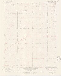
1974 Map of Scott City 4 SW
USGS Topo · Published 1976About this map
The High Plains of western Kansas are defined here by a systematic grid of section lines and the emerging energy infrastructure of the mid-1970s. This landscape, spanning the border of Finney Co and Gray Co, is organized into large-scale townships including Pleasant Valley, Pierceville, Garfield, and Logan. Unlike more settled regions, the primary indicators of industrial activity are the numerous scattered Gas Wells and generic Wells that punctuate the prairie, indicating the development of the Hugoton gas area or similar local fields. A central Oil Field highlights the region's economic reliance on subsurface mineral extraction. The map provides a clear look at the sparse, open character of the plains before more modern intensive agricultural or infrastructure shifts, focusing on the essential landmarks of water and energy points that sustained the local economy.
Find a feature on this map
8 named features on this map. Tap any name to fly to it.
Don’t see what you’re looking for? This feature index may not catch every label — zoom into the map to look around manually.
Map Details
Editions of this 1974 Scott City 4 SW Map
2 editions found
Other maps of this area

1896 · Garden
USGS Topo · 1:125,000

1944 · Tennis
USGS Topo · 1:62,500

1955 · Dodge City
USGS Topo · 1:250,000

1955 · Scott City
USGS Topo · 1:250,000

1958 · Dodge City
USGS Topo · 1:250,000

1958 · Scott City
USGS Topo · 1:250,000

1959 · Dodge City
USGS Topo · 1:250,000

1960 · Garden City East
USGS Topo · 1:24,000

1967 · Pierceville
USGS Topo · 1:24,000
1968 · Pierceville NE
USGS Topo · 1:24,000