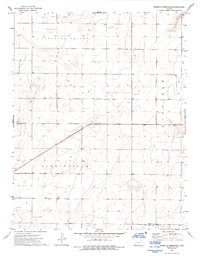
1974 Map of North of Pierceville
USGS Topo · Published 1993About this map
Pleasant Valley and Pierceville define the vast, open high plains of western Kansas in the mid-1970s. This survey records a landscape shaped by section-line roads and the emergence of the regional energy economy, characterized by the frequent presence of Gas Wells dotting the township grids. The terrain is divided into large rectangular blocks, reflecting the systematic land management of Logan and Garfield townships. Located along the border of Finney and Gray counties, the area is bisected by the diagonal route of highway 156, which cuts across the predominantly north-south and east-west orientation of the local agricultural and gas-field tracks. This map provides a precise record of the infrastructure supporting rural Kansas life and industry during a period of steady energy development.
Find a feature on this map
7 named features on this map. Tap any name to fly to it.
Don’t see what you’re looking for? This feature index may not catch every label — zoom into the map to look around manually.
Map Details
Editions of this 1974 North of Pierceville Map
2 editions found
Other maps of this area

1896 · Garden
USGS Topo · 1:125,000

1944 · Tennis
USGS Topo · 1:62,500

1955 · Dodge City
USGS Topo · 1:250,000

1955 · Scott City
USGS Topo · 1:250,000

1958 · Dodge City
USGS Topo · 1:250,000

1958 · Scott City
USGS Topo · 1:250,000

1959 · Dodge City
USGS Topo · 1:250,000

1960 · Garden City East
USGS Topo · 1:24,000

1967 · Pierceville
USGS Topo · 1:24,000
1968 · Pierceville NE
USGS Topo · 1:24,000