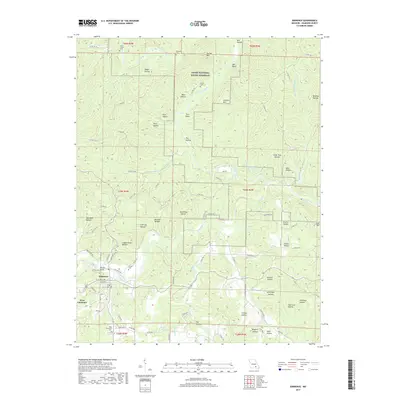
2017 Map of Eminence
USGS Topo · Published 2017About this map
Eminence serves as the focal point for this survey of the Missouri Ozarks, situated at the confluence where Jacks Fork meets the surrounding timbered hills. The map highlights a landscape dominated by the Ozark National Scenic Riverway, following the winding course of the Current River and its numerous tributaries like Shawnee Cr and Storys Cr. Significant elevation changes are marked by prominent peaks such as Tip Top Mtn, Jerktail Mtn, and Coot Mtn, while the terrain is deeply incised by dozens of named hollows including Dugan Hollow and Cedar Pole Hollow. Local history is preserved through the locations of several burial grounds, from the New Eminence Cem south of town to the more remote Lower Grassy Cem and Williams Cem in the north. The geography reveals a community built around the river system, with West Eminence linked by a network of winding county roads.
Find a feature on this map
111 named features on this map. Tap any name to fly to it.
Don’t see what you’re looking for? This feature index may not catch every label — zoom into the map to look around manually.
Map Details
Editions of this 2017 Eminence Map
This is the sole edition of this map. No revisions or reprints were ever made.
Other maps of this area

1915 · Eminence
USGS Topo · 1:62,500

1917 · Eminence
USGS Topo · 1:62,500

1928 · Cardareva
USGS Topo · 1:62,500

1944 · Corridon
USGS Topo · 1:62,500

1945 · Round Spring
USGS Topo · 1:62,500

1947 · Sinkin
USGS Topo · 1:48,000

1947 · Corridon
USGS Topo · 1:62,500

1949 · Round Spring
USGS Topo · 1:62,500

1949 · Rolla
USGS Topo · 1:250,000

1949 · Cardareva
USGS Topo · 1:62,500