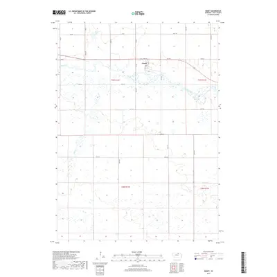
2017 Map of Emmet
USGS Topo · Published 2017About this map
Emmet serves as the central hub of this Holt County landscape, situated along the northern bank of the Elkhorn River. The town's grid is anchored by Front St and an adjacent section of Old Hwy, reflecting a settlement pattern tied closely to the river valley's east-west transit corridor. The surrounding terrain is characterized by the expansive wetland systems of the Nebraska Sandhills, particularly evident in the intricate drainages of Holt Cr and the isolated waters of Welsh Lake to the northwest. This 2017 survey details a rural economy defined by a dense network of section-line roads, including 874th Rd and 869th Rd, which carve the landscape into the traditional townships of t29n r13w and its neighbors.
Find a feature on this map
17 named features on this map. Tap any name to fly to it.
Don’t see what you’re looking for? This feature index may not catch every label — zoom into the map to look around manually.
Map Details
Editions of this 2017 Emmet Map
This is the sole edition of this map. No revisions or reprints were ever made.
Other maps of this area
1954 · Atkinson SE
USGS Topo · 1:24,000
1954 · Atkinson
USGS Topo · 1:24,000
1954 · Meek SW
USGS Topo · 1:24,000
1955 · O'Neill
USGS Topo · 1:250,000
1958 · O'Neill
USGS Topo · 1:24,000
1959 · O'Neill
USGS Topo · 1:250,000
1964 · Emmet NW
USGS Topo · 1:24,000
1964 · Emmet SE
USGS Topo · 1:24,000
1964 · Emmet SW
USGS Topo · 1:24,000
1964 · O'Neill SW
USGS Topo · 1:24,000