
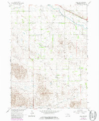
1964 Map of Emmet NW
USGS Topo · Published 1965About this map
The Elkhorn River winds through the northern portion of this Nebraska landscape, providing a vital waterway alongside the Chicago and North Western railroad. This 1964 survey captures a rural landscape in Holt County defined by a dispersed network of one-room schoolhouses, including School No 35, School No 81, and School No 99, which served the outlying agricultural community. The terrain transition is marked by Dry Creek in the northwest and Holt Creek in the south, reflecting a topography managed for ranching and farming. In the southern reaches, a Flowing Well and localized infrastructure like the Gravel Pit indicate the practical resource management of the era. The mapping of the Sheridan area provides a clear view of the section lines and rural drainage patterns that dictated the development of this section of the Missouri River Basin.
Find a feature on this map
10 named features on this map. Tap any name to fly to it.
Don’t see what you’re looking for? This feature index may not catch every label — zoom into the map to look around manually.
Map Details
Editions of this 1964 Emmet NW Map
2 editions found
Other maps of this area

1954 · Atkinson SE
USGS Topo · 1:24,000

1954 · Atkinson
USGS Topo · 1:24,000

1954 · Stuart SE
USGS Topo · 1:24,000

1955 · O'Neill
USGS Topo · 1:250,000

1959 · O'Neill
USGS Topo · 1:250,000

1964 · Emmet SE
USGS Topo · 1:24,000

1964 · Emmet SW
USGS Topo · 1:24,000

1964 · Emmet
USGS Topo · 1:24,000

1969 · O'Neill
USGS Topo · 1:250,000
1982 · Cottonwood Lake
USGS Topo · 1:24,000