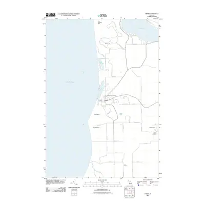
2011 Map of Empire
USGS Topo · Published 2011About this map
Empire stands as a central coastal hub in this 2011 survey of the Leelanau Peninsula shoreline. The village is flanked by the distinct waters of North Bar Lake and South Bar Lake, separated from the expansive Lake Michigan by narrow strips of dunes. The landscape is defined by massive glacial features, including the towering Empire Bluffs and Old Baldy Dune to the south, while the northern extent reaches toward The Sleeping Bear and Shauger Hill. Inland, the map reveals a grid of rural roads and residential enclaves like those near Taylor Lake and the southern edge of Glen Lake. Local genealogy and community infrastructure are well-documented through sites such as the Empire Catholic Cemetery, the Platte Cemetery near Otter Creek, and the Empire Post Office. The presence of the Empire Airport and Empire Township Campground highlights the area's modern role as a destination for recreation and small-craft aviation.
Find a feature on this map
51 named features on this map. Tap any name to fly to it.
Don’t see what you’re looking for? This feature index may not catch every label — zoom into the map to look around manually.
Map Details
Editions of this 2011 Empire Map
This is the sole edition of this map. No revisions or reprints were ever made.
Other maps of this area

1954 · Traverse City
USGS Topo · 1:250,000

1954 · Manitowoc
USGS Topo · 1:250,000

1956 · Thompsonville
USGS Topo · 1:62,500

1956 · Frankfort
USGS Topo · 1:62,500

1957 · Empire
USGS Topo · 1:62,500

1957 · Maple City
USGS Topo · 1:62,500

1958 · Traverse City
USGS Topo · 1:250,000

1958 · Manitowoc
USGS Topo · 1:250,000

1976 · Frankfort NW
USGS Topo · 1:24,000

1976 · Thompsonville NW
USGS Topo · 1:24,000