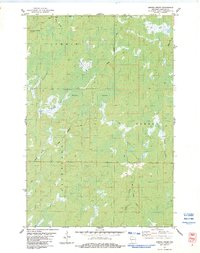
1983 Map of Empire Swamp
USGS Topo · Published 1983About this map
Empire Swamp dominates this northern Wisconsin landscape at the intersection of Summit, Gordon, and Dairyland townships. The map documents a territory defined by its dense hydrology, where Upper Tamarack River and Crotte Creek thread through marshy lowlands. High points are few, notably marked by the Summit Lookout Tower, which served as a primary vantage point for fire detection across the surrounding timberlands.
Find a feature on this map
17 named features on this map. Tap any name to fly to it.
Don’t see what you’re looking for? This feature index may not catch every label — zoom into the map to look around manually.
Map Details
Editions of this 1983 Empire Swamp Map
This is the sole edition of this map. No revisions or reprints were ever made.
Other maps of this area

1945 · Solon Springs
USGS Topo · 1:48,000

1947 · Minong
USGS Topo · 1:48,000

1949 · Solon Springs
USGS Topo · 1:48,000

1949 · Minong
USGS Topo · 1:48,000

1949 · Webb Lake
USGS Topo · 1:48,000

1949 · Patzau
USGS Topo · 1:48,000

1953 · Ashland
USGS Topo · 1:250,000

1953 · Duluth
USGS Topo · 1:250,000

1954 · Amnicon Lake
USGS Topo · 1:24,000
1954 · Patzau
USGS Topo · 1:24,000