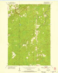
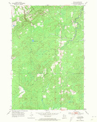
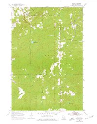
1954 Map of Patzau
USGS Topo · Published 1955About this map
Patzau serves as the primary settlement on this mid-century survey of the town of Summit in Douglas County. The landscape is defined by the winding course of the Black River and several isolated water bodies, including Summit Lake, Breitzman Lake, and Lake Seventeen. The infrastructure of the era is represented by the Minneapolis St Paul and Sault Ste Marie railroad line and an Old Railroad Grade that cuts through the forested sections, suggesting an evolving transportation network as older tracks were bypassed.
Find a feature on this map
15 named features on this map. Tap any name to fly to it.
Don’t see what you’re looking for? This feature index may not catch every label — zoom into the map to look around manually.
Map Details
Editions of this 1954 Patzau Map
4 editions found
Historical Maps of Summit Through Time
58 maps found

1945 Highland
Douglas County, WI

1949 Highland
Douglas County, WI

1949 Patzau
Douglas County, WI

1954 Amnicon Lake
Douglas County, WI

1954 Borea
Douglas County, WI

1954 Cloverland
Douglas County, WI

1954 Foxboro
Douglas County, WI

1954 Lyman Lake
Douglas County, WI

1954 Parkland
Douglas County, WI

1954 Patzau
Douglas County, WI

1954 Poplar NE
Douglas County, WI

1954 South Range
Douglas County, WI

1954 Sunnyside
Douglas County, WI

1955 Patzau
Douglas County, WI

1961 Cloverland
Douglas County, WI

1961 Ellison Lake
Douglas County, WI

1961 Lyman Lake
Douglas County, WI

1971 Chittamo
Douglas County, WI

1971 Chittamo NE
Douglas County, WI

1981 Bennett
Douglas County, WI

1982 Buckety Creek
Douglas County, WI

1982 Minong Flowage
Douglas County, WI

1983 Black Lake
Douglas County, WI

1983 Dairyland
Douglas County, WI

1983 Empire Swamp
Douglas County, WI

1983 Moose Junction
Douglas County, WI

1983 Scovils Lake
Douglas County, WI

1984 Ellison Lake
Douglas County, WI

1984 Island Lake
Douglas County, WI

1984 Lake Minnesuing
Douglas County, WI

1984 Metzger Lake
Douglas County, WI

1984 Oulu
Douglas County, WI

2022 Amnicon Lake
Douglas County, WI

2022 Bennett
Douglas County, WI

2022 Black Lake
Douglas County, WI

2022 Borea
Douglas County, WI

2022 Buckety Creek
Douglas County, WI

2022 Chittamo
Douglas County, WI

2022 Chittamo NE
Douglas County, WI

2022 Cloverland
Douglas County, WI

2022 Dairyland
Douglas County, WI

2022 Ellison Lake
Douglas County, WI

2022 Empire Swamp
Douglas County, WI

2022 Foxboro
Douglas County, WI

2022 Island Lake
Douglas County, WI

2022 Lake Minnesuing
Douglas County, WI

2022 Lyman Lake
Douglas County, WI

2022 Metzger Lake
Douglas County, WI

2022 Minong Flowage
Douglas County, WI

2022 Moose Junction
Douglas County, WI

2022 Oulu
Douglas County, WI

2022 Oulu OE N
Douglas County, WI

2022 Parkland
Douglas County, WI

2022 Patzau
Douglas County, WI

2022 Poplar NE
Douglas County, WI

2022 Scovils Lake
Douglas County, WI

2022 South Range
Douglas County, WI

2022 Sunnyside
Douglas County, WI