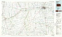
1985 Map of Emporia
USGS Topo · Published 1985About this map
The Cottonwood River and Neosho River converge near the regional hub of Emporia, where the landscape transitions into the distinct topography of the Flint Hills. This mid-1980s planimetric survey documents a vast network of tallgrass prairie drainage systems, including Diamond Creek, Middle Creek, and the Verdigris River. Transportation infrastructure is dominated by the Kansas Turnpike and the historic route of the Atchison Topeka and Santa Fe railroad, which links smaller agricultural settlements like Strong City, Elmdale, and Saffordville.
Find a feature on this map
86 named features on this map. Tap any name to fly to it.
Don’t see what you’re looking for? This feature index may not catch every label — zoom into the map to look around manually.
Map Details
Editions of this 1985 Emporia Map
2 editions found
Other maps of this area

1885 · Eskridge
USGS Topo · 1:125,000

1885 · Burlington
USGS Topo · 1:125,000

1885 · Eureka
USGS Topo · 1:125,000

1886 · Fredonia
USGS Topo · 1:125,000

1888 · Emporia
USGS Topo · 1:125,000

1888 · Eureka
USGS Topo · 1:125,000

1888 · Eldorado
USGS Topo · 1:125,000

1889 · Burlingame
USGS Topo · 1:125,000

1889 · Newton
USGS Topo · 1:125,000

1889 · Abilene
USGS Topo · 1:125,000