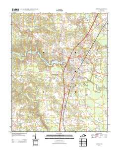
2013 Map of Emporia
USGS Topo · Published 2013About this map
The Meherrin River bisects this Southside Virginia landscape, serving as the central geographic feature for the city of Emporia. By the early 21st century, the area shows a distinct pattern of residential clusters including North Emporia, White City, and Washington Park, reflecting the town's growth as a regional hub. The infrastructure of the Emporia Waterworks and the Meherrin River Reservoir highlight the importance of the river to the local utility and recreation network.
Find a feature on this map
144 named features on this map. Tap any name to fly to it.
Don’t see what you’re looking for? This feature index may not catch every label — zoom into the map to look around manually.
Map Details
Editions of this 2013 Emporia Map
This is the sole edition of this map. No revisions or reprints were ever made.
Other maps of this area

1919 · Jarratt
USGS Topo · 1:62,500

1919 · Mc Kenney
USGS Topo · 1:48,000

1919 · Emporia
USGS Topo · 1:62,500

1919 · Arringdale
USGS Topo · 1:48,000

1920 · Arringdale
USGS Topo · 1:62,500

1921 · Mc Kenney
USGS Topo · 1:62,500

1942 · Arringdale
USGS Topo · 1:62,500

1942 · Emporia
USGS Topo · 1:62,500

1943 · Mc Kenney
USGS Topo · 1:62,500

1951 · Jarratt
USGS Topo · 1:62,500