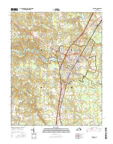
2016 Map of Emporia
USGS Topo · Published 2016About this map
The Meherrin River carves a path through this landscape, fueling the local economy via the Meherrin River Reservoir and Emporia Lake. The independent city of Emporia serves as a central hub, flanked by its northern counterpart, North Emporia, and several residential pockets such as Kingsberry, Westover Hills, and Washington Park. This modern survey reveals a community anchored by institutional and memorial landmarks, including the campus of Southside Virginia Community College and several sprawling burial grounds like Greensville Memorial Cemetery.
Find a feature on this map
117 named features on this map. Tap any name to fly to it.
Don’t see what you’re looking for? This feature index may not catch every label — zoom into the map to look around manually.
Map Details
Editions of this 2016 Emporia Map
This is the sole edition of this map. No revisions or reprints were ever made.
Other maps of this area

1919 · Jarratt
USGS Topo · 1:62,500

1919 · Mc Kenney
USGS Topo · 1:48,000

1919 · Emporia
USGS Topo · 1:62,500

1919 · Arringdale
USGS Topo · 1:48,000

1920 · Arringdale
USGS Topo · 1:62,500

1921 · Mc Kenney
USGS Topo · 1:62,500

1942 · Arringdale
USGS Topo · 1:62,500

1942 · Emporia
USGS Topo · 1:62,500

1943 · Mc Kenney
USGS Topo · 1:62,500

1951 · Jarratt
USGS Topo · 1:62,500