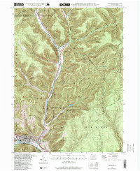
1994 Map of Emporium
USGS Topo · Published 1999About this map
Emporium serves as the focal point of this Pennsylvania forest landscape, where the confluence of Sinnemahoning Creek and West Creek dictates the path of local industry and infrastructure. This area, largely defined by the conservation lands of the Elk State Forest and Susquehannock State Forest, reveals a deep network of hollows such as Arnold Hol and Reese Hol that branch away from the main valley floors. The presence of Sizerville State Park and the nearby settlement of Sizerville underscore the region's importance for both recreation and timber history. Genealogists and local historians can trace the smaller residential pockets at Prospect Park and Gardeau, while the Newton Cem provides a specific point of interest for family research. Numerous designated trails, including the McDowell Trail and Switchback Trail, demonstrate how the steep terrain of the Pennsylvania Wilds has been navigated over the decades.
Find a feature on this map
59 named features on this map. Tap any name to fly to it.
Don’t see what you’re looking for? This feature index may not catch every label — zoom into the map to look around manually.
Map Details
Editions of this 1994 Emporium Map
2 editions found
Other maps of this area

1941 · Benezette
USGS Topo · 1:62,500

1943 · Benezette
USGS Topo · 1:62,500

1945 · Driftwood
USGS Topo · 1:48,000

1945 · First Fork
USGS Topo · 1:24,000

1945 · Cameron
USGS Topo · 1:24,000

1947 · Cameron
USGS Topo · 1:24,000

1947 · First Fork
USGS Topo · 1:24,000

1948 · Crosby
USGS Topo · 1:62,500

1948 · Emporium
USGS Topo · 1:62,500

1948 · Keating Summit
USGS Topo · 1:24,000