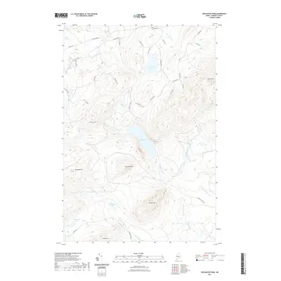
2021 Map of Enchanted Pond
USGS Topo · Published 2021About this map
Enchanted Pond sits at the heart of this high-elevation Maine landscape, surrounded by a complex network of peaks and drainage basins. The area is defined by significant elevations like Coburn Mtn and Shutdown Mtn, which overlook a series of smaller water bodies including the McKenney Ponds and Grace Pond. This modern survey reveals a landscape primarily accessed by a web of specialized timber and camp roads such as Grace Camps Rd, Slim Haggle Rd, and Larochelle Rd. The drainage pattern is intricate, with Enchanted Stream and the E Branch Enchanted Stream cutting through the steep contours, while Tobey Brook and Salmon Stream delineate the lower basins. The prevalence of named peaks like Granny Cap and Heald Mtn alongside these remote ponds suggests a region deeply tied to seasonal recreation and the North Woods timber economy.
Find a feature on this map
47 named features on this map. Tap any name to fly to it.
Don’t see what you’re looking for? This feature index may not catch every label — zoom into the map to look around manually.
Map Details
Editions of this 2021 Enchanted Pond Map
This is the sole edition of this map. No revisions or reprints were ever made.
Other maps of this area

1922 · Long Pond
USGS Topo · 1:62,500

1923 · Attean
USGS Topo · 1:62,500

1924 · Long Pond
USGS Topo · 1:62,500

1925 · Pierce Pond
USGS Topo · 1:48,000

1925 · Attean
USGS Topo · 1:62,500

1927 · Pierce Pond
USGS Topo · 1:62,500

1928 · Spencer
USGS Topo · 1:48,000

1932 · Spencer
USGS Topo · 1:62,500

1944 · Long Pond
USGS Topo · 1:62,500

1944 · Pierce Pond
USGS Topo · 1:62,500
Featured Places
- T3 R5 BKP WKR, ME
- Upper Enchanted Township, ME
- Johnson Mountain Township, ME
- Lower Enchanted Township, ME
- Bradstreet Township, ME