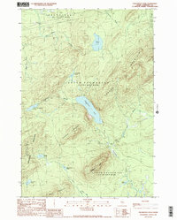
1989 Map of Enchanted Pond
USGS Topo · Published 1989About this map
Enchanted Pond sits at the heart of this Maine wilderness survey, which documents a landscape defined by industrial timberlands and topographic extremes in the late 1980s. The map covers several townships including Upper Enchanted, Lower Enchanted, and Hobbstown. A network of unpaved logging roads and trails threads between the peaks of Coburn Mountain and Hedgehog Mountain, highlighting the area's role in the regional resource economy. Notable water bodies such as Grace Pond, Little Enchanted Pond, and Gordon Pond are interconnected by waterways like Enchanted Stream and Bitter Brook. The presence of several Gravel Pits alongside these routes suggests active maintenance of the transport infrastructure required for forestry operations, while isolated peaks like Granny Cap and Johnson Mtn dominate the horizon.
Find a feature on this map
28 named features on this map. Tap any name to fly to it.
Don’t see what you’re looking for? This feature index may not catch every label — zoom into the map to look around manually.
Map Details
Editions of this 1989 Enchanted Pond Map
This is the sole edition of this map. No revisions or reprints were ever made.
Other maps of this area

1922 · Long Pond
USGS Topo · 1:62,500

1923 · Attean
USGS Topo · 1:62,500

1924 · Long Pond
USGS Topo · 1:62,500

1925 · Pierce Pond
USGS Topo · 1:48,000

1925 · Attean
USGS Topo · 1:62,500

1927 · Pierce Pond
USGS Topo · 1:62,500

1928 · Spencer
USGS Topo · 1:48,000

1932 · Spencer
USGS Topo · 1:62,500

1944 · Long Pond
USGS Topo · 1:62,500

1944 · Pierce Pond
USGS Topo · 1:62,500
Featured Places
- Upper Enchanted Township, ME
- Johnson Mountain Township, ME
- T3 R5 BKP WKR, ME
- Bradstreet Township, ME
- Hobbstown Township, ME