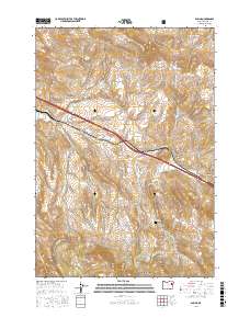
2017 Map of Encina
USGS Topo · Published 2017About this map
Virtue Hills rise above the high desert landscape of Baker County, where the historic route of Old US Hwy 30 traces a path through the small settlements of Encina and Pleasant Valley. This 2017 survey illustrates the enduring intersection of early transportation corridors and mountain geography, with modern Interstate 84 following the established trail of the pioneer highway. The map provides essential details for genealogists, marking the Pleasant Valley Cem and several family-named water sources like Johnston Spring. To the south, the terrain becomes increasingly complex as the boundaries of the Whitman National Forest encompass the headwaters of Alder Cr and Sutton Cr. The presence of features like Dogtown Cr and White Swan Gulch reflects the area's rich history of early land claims and prospecting.
Find a feature on this map
30 named features on this map. Tap any name to fly to it.
Don’t see what you’re looking for? This feature index may not catch every label — zoom into the map to look around manually.
Map Details
Editions of this 2017 Encina Map
This is the sole edition of this map. No revisions or reprints were ever made.
Other maps of this area
1901 · Baker City
USGS Topo · 1:125,000

1955 · Baker
USGS Topo · 1:250,000

1959 · Baker
USGS Topo · 1:250,000

1967 · Virtue Flat
USGS Topo · 1:24,000
1967 · Encina
USGS Topo · 1:24,000
1967 · Baker
USGS Topo · 1:24,000
1967 · Keating
USGS Topo · 1:24,000
1967 · French Gulch
USGS Topo · 1:24,000

1967 · Dooley Mtn
USGS Topo · 1:24,000
1967 · Lost Basin
USGS Topo · 1:24,000