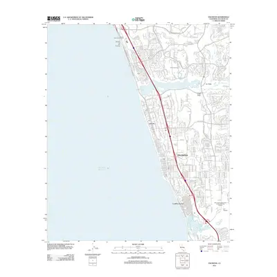
2012 Map of Encinitas
USGS Topo · Published 2012About this map
Batiquitos Lagoon and San Elijo Lagoon punctuate the North County coastline, framing the dense residential and coastal corridors of this southern California stretch. The Nctd Rr and Carlsbad Blvd run parallel to the shore, passing through established communities like Leucadia and Cardiff-by-the-Sea. Inland, the landscape transitions from the coastal bluffs to planned developments and recreational spaces such as the Aviara Golf Course and La Costa.
Find a feature on this map
177 named features on this map. Tap any name to fly to it.
Don’t see what you’re looking for? This feature index may not catch every label — zoom into the map to look around manually.
Map Details
Editions of this 2012 Encinitas Map
This is the sole edition of this map. No revisions or reprints were ever made.
Other maps of this area

1893 · Oceanside
USGS Topo · 1:62,500

1893 · Escondido
USGS Topo · 1:62,500

1898 · Oceanside
USGS Topo · 1:62,500

1901 · Escondido
USGS Topo · 1:62,500

1901 · Oceanside
USGS Topo · 1:62,500

1901 · San Luis Rey
USGS Topo · 1:125,000

1903 · La Jolla
USGS Topo · 1:62,500

1904 · Southern California Sheet No. 2
USGS Topo · 1:250,000

1930 · La Jolla
USGS Topo · 1:62,500
1942 · Oceanside
USGS Topo · 1:62,500