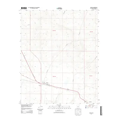
2013 Map of Encino
USGS Topo · Published 2013About this map
Encino sits as the central point of this High Plains landscape, where the intersection of regional transport routes defines the local geography. The village structure is oriented along the path of the southern rail line and Railroad Ave, flanked by the Encino Cem and Guadalupe Cem. This survey illustrates a quiet crossroads economy centered around the Po and the convergence of Us-60, Us-285, and Nm-3. To the northeast, the natural topography is marked by the Amarillo Draw, which cuts through the township sections. Further southeast, the small settlement of Carnero appears along the highway corridor, showing the sparse but persistent habitation patterns of Torrance County. The map provides a clear view of the rural road network, including CO Road C077 and CO Road C083, which connect the outlying ranch lands to the village core.
Find a feature on this map
20 named features on this map. Tap any name to fly to it.
Don’t see what you’re looking for? This feature index may not catch every label — zoom into the map to look around manually.
Map Details
Editions of this 2013 Encino Map
This is the sole edition of this map. No revisions or reprints were ever made.
Other maps of this area
1954 · Fort Sumner
USGS Topo · 1:250,000
1958 · Fort Sumner
USGS Topo · 1:250,000
1978 · North Lucy
USGS Topo · 1:24,000
1978 · Santa Barbara Lake
USGS Topo · 1:24,000
1978 · Tejon
USGS Topo · 1:24,000
1978 · Santo Nino Canyon
USGS Topo · 1:24,000
1978 · Encino
USGS Topo · 1:24,000
1978 · Negra SE
USGS Topo · 1:24,000
1978 · Negra
USGS Topo · 1:24,000
1978 · Dunlap Ranch
USGS Topo · 1:24,000