
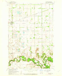
1961 Map of Enderlin North
USGS Topo · Published 1963About this map
The Maple River snakes through the southern portion of this 1961 survey, where the town of Enderlin straddles the boundary between Cass and Ransom Counties. This landscape is defined by the rectilinear grid of township boundaries, including Liberty, Pontiac, and Clifton, which organize the agricultural plains. Transportation and commerce are centered around the Northern Pacific railroad corridor in the north and the municipal developments in the south, such as Sky Haven Ranch Airport and the greenery of Patrick Pierce Park.
Find a feature on this map
16 named features on this map. Tap any name to fly to it.
Don’t see what you’re looking for? This feature index may not catch every label — zoom into the map to look around manually.
Map Details
Editions of this 1961 Enderlin North Map
This is the sole edition of this map. No revisions or reprints were ever made.
Other maps of this area

1895 · Casselton
USGS Topo · 1:125,000

1897 · Tower
USGS Topo · 1:125,000

1897 · Casselton
USGS Topo · 1:125,000

1953 · Fargo
USGS Topo · 1:250,000

1956 · Fargo
USGS Topo · 1:250,000

1960 · Enderlin South
USGS Topo · 1:24,000
1960 · Sheldon
USGS Topo · 1:24,000

1961 · Sheldon NW
USGS Topo · 1:24,000

1965 · Alice
USGS Topo · 1:24,000

1965 · Lucca
USGS Topo · 1:24,000