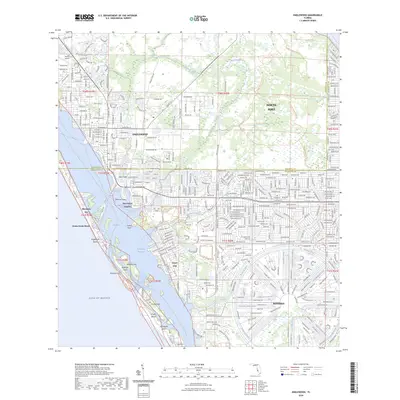
2024 Map of Englewood
USGS Topo · Published 2024About this map
Englewood and the unique circular development of Rotonda anchor this coastal Florida landscape, where the land is defined by an intricate network of man-made and natural waterways. To the north, the Myakka State Forest provides a buffer of preserved land, while the coast is shielded by a string of barrier islands including Manasota Key, Peterson Island, and Don Pedro Island. The Intracoastal Waterway threads through Lemon Bay, separating the mainland settlements of Grove City and New Point Comfort from the Gulf beaches.
Find a feature on this map
47 named features on this map. Tap any name to fly to it.
Don’t see what you’re looking for? This feature index may not catch every label — zoom into the map to look around manually.
Map Details
Editions of this 2024 Englewood Map
This is the sole edition of this map. No revisions or reprints were ever made.
Other maps of this area

1944 · Myakka River
USGS Topo · 1:31,680

1944 · Venice
USGS Topo · 1:31,680

1956 · Murdock
USGS Topo · 1:24,000

1956 · Englewood
USGS Topo · 1:24,000

1956 · Tampa
USGS Topo · 1:250,000

1956 · Charlotte Harbor
USGS Topo · 1:250,000

1957 · Englewood NW
USGS Topo · 1:24,000

1957 · El Jobean
USGS Topo · 1:24,000

1957 · Punta Gorda SW
USGS Topo · 1:24,000

1957 · Placida
USGS Topo · 1:24,000