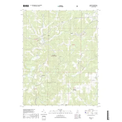
2019 Map of English
USGS Topo · Published 2019About this map
English stands as a central community within the winding valleys of the Hoosier National Forest in Crawford County. This survey reveals a landscape deeply carved by the Little Blue River and its numerous tributaries, including Bird Hollow Cr, Brownstown Cr, and Brushy Cr. The map details a high density of small rural burial grounds that speak to the area's genealogical history, from the Sloan Cem near the town center to the remote Cunningham Cem and Mount Sterling Cem further south. These sites, often positioned on high ground above the creek beds, provide a literal map of family settlement patterns throughout the township boundaries of t2s r1w and t2s r1e. Beyond the town of English, smaller crossroads and communities like Grantsburg, Temple, and Switzer Crossroads illustrate the dispersed nature of local commerce and residency in this forested region.
Find a feature on this map
65 named features on this map. Tap any name to fly to it.
Don’t see what you’re looking for? This feature index may not catch every label — zoom into the map to look around manually.
Map Details
Editions of this 2019 English Map
This is the sole edition of this map. No revisions or reprints were ever made.
Other maps of this area

1946 · Leavenworth
USGS Topo · 1:24,000

1947 · Leavenworth
USGS Topo · 1:24,000

1947 · Hardinsburg
USGS Topo · 1:24,000

1948 · Milltown
USGS Topo · 1:24,000

1949 · Hardinsburg
USGS Topo · 1:24,000

1950 · Beechwood
USGS Topo · 1:24,000

1950 · Valeene
USGS Topo · 1:24,000

1950 · English
USGS Topo · 1:24,000
1950 · Leavenworth
USGS Topo · 1:24,000

1950 · Alton
USGS Topo · 1:62,500