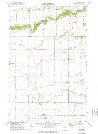
1974 Map of Enok
USGS Topo · Published 1976About this map
The South Branch Two Rivers meanders through the heart of Kittson County, defining a landscape of wetlands and drainage improvements in the townships of Thompson, Tegner, and Jupiter. This mid-1970s survey illustrates a rural region where small community centers like Enok and Jupiter serve as anchors for the surrounding agricultural community. The map reveals an intricate network of waterways including Lake Wold, Two Rivers, and artificial structures like County Ditch No 8 and State Ditch No 1, which were critical for managing the low-lying terrain.
Find a feature on this map
25 named features on this map. Tap any name to fly to it.
Don’t see what you’re looking for? This feature index may not catch every label — zoom into the map to look around manually.
Map Details
Editions of this 1974 Enok Map
This is the sole edition of this map. No revisions or reprints were ever made.
Other maps of this area

1918 · Hemmington
USGS Topo · 1:62,500

1939 · Kennedy
USGS Topo · 1:62,500

1941 · Kennedy
USGS Topo · 1:62,500

1941 · Hallock
USGS Topo · 1:62,500

1952 · Thief River Falls
USGS Topo · 1:250,000

1956 · Thief River Falls
USGS Topo · 1:250,000

1956 · Karlstad
USGS Topo · 1:62,500

1957 · Thief River Falls
USGS Topo · 1:250,000
1966 · Skull Lake SW
USGS Topo · 1:24,000

1967 · Thief River Falls
USGS Topo · 1:250,000