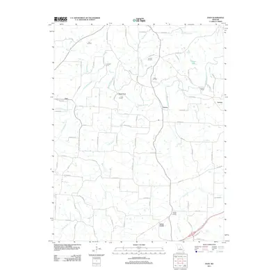
2011 Map of Enon
USGS Topo · Published 2011About this map
South Moreau Creek meanders across this rural landscape, providing the primary drainage for a region defined by its small farming communities and historic river crossings. The map reveals a network of local importance centered around Payne Ford and Campbell Ford, reflecting an era when these river points were essential for transit before modern bridge infrastructure became ubiquitous. While McCann Bridge serves the northeastern corner, the legacy of earlier settlement patterns is visible through numerous family and community burial grounds, including the Enloe Cemetery and Roark Cemetery. To the south, the village of Spring Garden sits near the headwaters of Brush Creek, while the settlement of Enon anchors the northwestern quadrant. The map also documents localized landmarks like Flint Hill and the waters of Winegar Lake, illustrating a quiet, agrarian character that has persisted into the 21st century.
Find a feature on this map
85 named features on this map. Tap any name to fly to it.
Don’t see what you’re looking for? This feature index may not catch every label — zoom into the map to look around manually.
Map Details
Editions of this 2011 Enon Map
This is the sole edition of this map. No revisions or reprints were ever made.
Other maps of this area

1886 · Jefferson City
USGS Topo · 1:125,000

1888 · Versailles
USGS Topo · 1:125,000

1888 · Tuscumbia
USGS Topo · 1:125,000

1888 · Boonville
USGS Topo · 1:125,000

1893 · Versailles
USGS Topo · 1:125,000

1894 · Tuscumbia
USGS Topo · 1:125,000

1894 · Jefferson City
USGS Topo · 1:125,000

1904 · Eldon
USGS Topo · 1:62,500
1935 · Eldon
USGS Topo · 1:24,000

1947 · Jefferson City
USGS Topo · 1:250,000