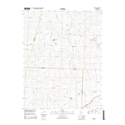
2015 Map of Enon
USGS Topo · Published 2015About this map
South Moreau Creek and its many tributaries, including Morgan Br and Roark Br, carve a complex drainage pattern through this section of Central Missouri. The map centers on a rural landscape defined by small settlements and family burial grounds that anchor the local history of Cole, Miller, and Moniteau Counties. The crossing at Payne Ford and the location of McCann Bridge over the creek highlight the historical importance of water crossings in a region where the road network, including Route A and Mo-V, follows the winding topography.
Find a feature on this map
88 named features on this map. Tap any name to fly to it.
Don’t see what you’re looking for? This feature index may not catch every label — zoom into the map to look around manually.
Map Details
Editions of this 2015 Enon Map
This is the sole edition of this map. No revisions or reprints were ever made.
Other maps of this area

1886 · Jefferson City
USGS Topo · 1:125,000

1888 · Versailles
USGS Topo · 1:125,000

1888 · Tuscumbia
USGS Topo · 1:125,000

1888 · Boonville
USGS Topo · 1:125,000

1893 · Versailles
USGS Topo · 1:125,000

1894 · Tuscumbia
USGS Topo · 1:125,000

1894 · Jefferson City
USGS Topo · 1:125,000

1904 · Eldon
USGS Topo · 1:62,500
1935 · Eldon
USGS Topo · 1:24,000

1947 · Jefferson City
USGS Topo · 1:250,000