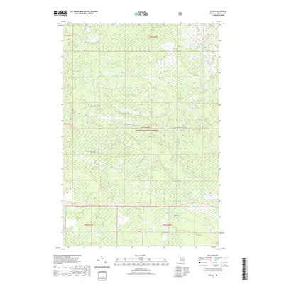
2019 Map of Ensign
USGS Topo · Published 2019About this map
The settlement of Ensign is situated at a crossroads in Delta County, serving as a gateway to the expansive Hiawatha National Forest. This terrain is defined by a dense network of tributaries including the W Br Ogontz River and Mormon Cr, which navigate a landscape of significant wetlands like Halman Marsh. The presence of Ogontz Cem and Johnston Cem near Johnston Cr provides critical markers for genealogists and local historians documenting the early families of the area. Modern recreation is well-established through the Big Bay De Noc Snomo (Snow) and the 2231 OHV Trail, reflecting the transition from timber extraction to a recreational economy within the forest boundaries. Numerous small water bodies, such as Peterson Lake and the Lost Lakes, are scattered throughout the northern sections, illustrating the glacial hydrography of the Upper Peninsula.
Find a feature on this map
22 named features on this map. Tap any name to fly to it.
Don’t see what you’re looking for? This feature index may not catch every label — zoom into the map to look around manually.
Map Details
Editions of this 2019 Ensign Map
This is the sole edition of this map. No revisions or reprints were ever made.
Other maps of this area

1932 · Rapid River NE
USGS Topo · 1:31,680

1932 · Trenary SW
USGS Topo · 1:31,680

1932 · Garden NW and SW
USGS Topo · 1:31,680

1932 · Rapid River NW
USGS Topo · 1:31,680

1932 · Trenary SE
USGS Topo · 1:31,680

1932 · Rapid River SE
USGS Topo · 1:31,680

1932 · Skeels Lake NW and SW
USGS Topo · 1:31,680

1932 · Rapid River SW
USGS Topo · 1:31,680

1954 · Escanaba
USGS Topo · 1:250,000

1957 · Escanaba
USGS Topo · 1:250,000