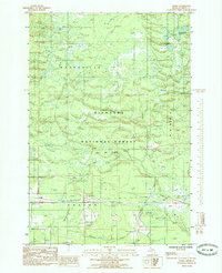
1985 Map of Ensign
USGS Topo · Published 1985About this map
Hiawatha National Forest covers much of this landscape in Delta County, where the transition from dense woodland to low-lying wetlands is marked by the expansive Malman Marsh. Near the southern boundary, the small settlement of Ensign is situated along the primary roadway, while the remote Johnston area is defined by its namesake Johnston Cem and a nearby Limestone Quarry. The region's industrial and recreational history is reflected in several Sand Pits and the long stretch of the Nahma Grade, which follows an old transport corridor. Water is a defining element across the quadrangle, with numerous interior lakes like Peterson Lake, Ramsey Lake, and the Lost Lakes feeding into a network of drainages including Bills Creek, Mormon Creek, and Ogontz Creek. A dedicated Snowmobile Trail and a series of Pipe Lines cut through the forest, indicating the modern utility of this Michigan timberland.
Find a feature on this map
25 named features on this map. Tap any name to fly to it.
Don’t see what you’re looking for? This feature index may not catch every label — zoom into the map to look around manually.
Map Details
Editions of this 1985 Ensign Map
This is the sole edition of this map. No revisions or reprints were ever made.
Other maps of this area

1932 · Rapid River NE
USGS Topo · 1:31,680

1932 · Trenary SW
USGS Topo · 1:31,680

1932 · Garden NW and SW
USGS Topo · 1:31,680

1932 · Rapid River NW
USGS Topo · 1:31,680

1932 · Trenary SE
USGS Topo · 1:31,680

1932 · Rapid River SE
USGS Topo · 1:31,680

1932 · Skeels Lake NW and SW
USGS Topo · 1:31,680

1932 · Rapid River SW
USGS Topo · 1:31,680

1954 · Escanaba
USGS Topo · 1:250,000

1957 · Escanaba
USGS Topo · 1:250,000