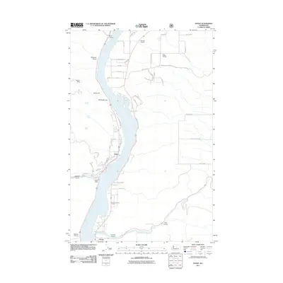
2011 Map of Entiat
USGS Topo · Published 2011About this map
The Columbia River serves as the central artery for this region of Washington, where the community of Entiat sits on the western bank and Orondo occupies the eastern shore. The landscape is defined by dramatic geological features such as Ribbon Cliff, Earthquake Point, and the high elevation of Ribbon Mesa. This 2011 survey captures the area's agricultural and residential development, evidenced by the Entiat Ditch and numerous rural roads like Brays Rd and Nels Nelson Rd NW. Local history is anchored by the Brays Landing Cemetery and Orondo Community Cemetery, which provide vital genealogical links. The map also traces the drainage patterns through many named canyons, including Byrd Canyon and Corbaley Canyon, illustrating how the Entiat Valley is shaped by these seasonal watercourses and springs like Coyote Spring.
Find a feature on this map
53 named features on this map. Tap any name to fly to it.
Don’t see what you’re looking for? This feature index may not catch every label — zoom into the map to look around manually.
Map Details
Editions of this 2011 Entiat Map
This is the sole edition of this map. No revisions or reprints were ever made.
Other maps of this area

1901 · Chelan
USGS Topo · 1:125,000

1957 · Wenatchee
USGS Topo · 1:250,000

1968 · Chelan
USGS Topo · 1:24,000

1968 · Orondo
USGS Topo · 1:24,000

1968 · Waterville
USGS Topo · 1:24,000

1968 · Entiat
USGS Topo · 1:24,000

1968 · Ardenvoir
USGS Topo · 1:24,000

1968 · Baldy Mtn
USGS Topo · 1:24,000
1968 · Douglas
USGS Topo · 1:24,000

1968 · Winesap
USGS Topo · 1:24,000