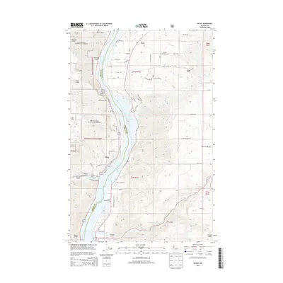
2014 Map of Entiat
USGS Topo · Published 2014About this map
Lake Entiat and the Columbia River dominate this Central Washington landscape, marking the boundary between Chelan and Douglas counties. The settlement of Entiat is situated along the western bank, where the Entiat River flows into the reservoir. This area demonstrates a complex irrigation and water management system, evidenced by the Entiat Ditch winding through Entiat Valley. To the west, the steep terrain of the Wenatchee National Forest rises sharply, featuring distinctive landmarks like Ribbon Cliff and Earthquake Point. Conversely, the eastern side of the river transitions into the Waterville Plateau, characterized by deep cuts such as Browns Canyon and Pine Canyon. Local heritage is anchored by sites like the Brays Landing Cem and Orondo Community Cem, which serve as touchpoints for families tied to the river's historic transport and orchard economy.
Find a feature on this map
76 named features on this map. Tap any name to fly to it.
Don’t see what you’re looking for? This feature index may not catch every label — zoom into the map to look around manually.
Map Details
Editions of this 2014 Entiat Map
This is the sole edition of this map. No revisions or reprints were ever made.
Other maps of this area

1901 · Chelan
USGS Topo · 1:125,000

1957 · Wenatchee
USGS Topo · 1:250,000

1968 · Chelan
USGS Topo · 1:24,000

1968 · Orondo
USGS Topo · 1:24,000

1968 · Waterville
USGS Topo · 1:24,000

1968 · Entiat
USGS Topo · 1:24,000

1968 · Ardenvoir
USGS Topo · 1:24,000

1968 · Baldy Mtn
USGS Topo · 1:24,000
1968 · Douglas
USGS Topo · 1:24,000

1968 · Winesap
USGS Topo · 1:24,000