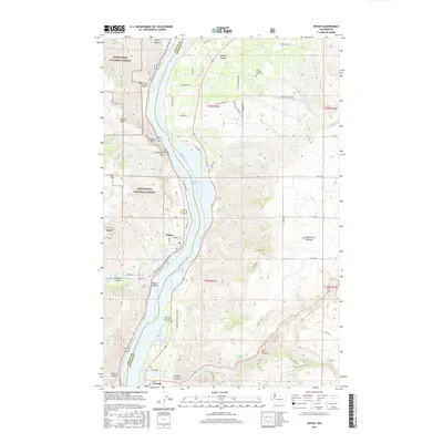
2017 Map of Entiat
USGS Topo · Published 2017About this map
Lake Entiat and the Columbia River dominate this modern geographic study of the corridor between Chelan and Douglas counties. The settlement of Entiat sits at the confluence of the Columbia and the Entiat River, where the Entiat Ditch provides a glimpse into the irrigation history of this arid orchard region. The topography rises sharply from the riverbanks to the Waterville Plateau in the east and the Wenatchee National Forest to the west. Landmarks like Ribbon Cliff and Earthquake Point suggest a landscape shaped by significant geological events. Further south, the community of Orondo serves as a hub for local agriculture, supported by a network of roads such as the Orondo Orchards Loop Rd that wind through the surrounding canyons and mesas.
Find a feature on this map
69 named features on this map. Tap any name to fly to it.
Don’t see what you’re looking for? This feature index may not catch every label — zoom into the map to look around manually.
Map Details
Editions of this 2017 Entiat Map
This is the sole edition of this map. No revisions or reprints were ever made.
Other maps of this area

1901 · Chelan
USGS Topo · 1:125,000

1957 · Wenatchee
USGS Topo · 1:250,000

1968 · Chelan
USGS Topo · 1:24,000

1968 · Orondo
USGS Topo · 1:24,000

1968 · Waterville
USGS Topo · 1:24,000

1968 · Entiat
USGS Topo · 1:24,000

1968 · Ardenvoir
USGS Topo · 1:24,000

1968 · Baldy Mtn
USGS Topo · 1:24,000
1968 · Douglas
USGS Topo · 1:24,000

1968 · Winesap
USGS Topo · 1:24,000