2022 Map of Ephraim
USGS Topo · Published 2022About this map
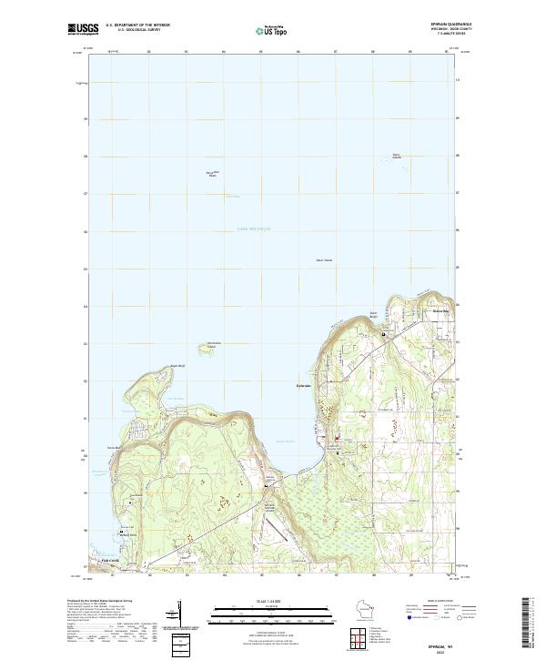
Ephraim and Sister Bay anchor this coastal study of the Door Peninsula, where the landscape is defined by its relation to Green Bay and Lake Michigan. The map details the jagged shoreline between Fish Creek and Sister Bay, highlighting the prominent limestone formations of Eagle Bluff and Svens Bluff. This 2022 survey captures a mix of maritime heritage and preserved natural spaces, from the protected waters of Eagle Harbor to the extensive Ephraim Swamp and the inland reaches of Ephraim Cr. Genealogists will find several distinct burial sites recorded, including Pioneer Cem, Blossomberg Cem, and the Ephraim Moravian Cem. The transportation network is a blend of land and water, featuring the Ephraim-Gibraltar Airport alongside modern roads like Skyline RD and the designated Water Trail that skirts the coastline near Horseshoe Island and the Sister Shoals.
Find a feature on this map
70 named features on this map. Tap any name to fly to it.
Don’t see what you’re looking for? This feature index may not catch every label — zoom into the map to look around manually.
Map Details
Editions of this 2022 Ephraim Map
This is the sole edition of this map. No revisions or reprints were ever made.