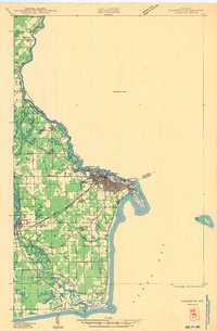
1981 Map of Marinette
USGS Topo · Published 1982About this map
The Menominee River serves as the focal point for this 1980s landscape, marking the border between Wisconsin and Michigan while connecting the sister cities of Marinette and Menominee. The map illustrates a region defined by its timber and water history, featuring expansive tracts like the Escanaba River State Forest and the J.W. Wells State Park. Inland, the terrain is dotted with substantial water bodies like Lake Noquebay and the winding Peshtigo River, which flow through small settlements such as Crivitz and Loomis.
Find a feature on this map
107 named features on this map. Tap any name to fly to it.
Don’t see what you’re looking for? This feature index may not catch every label — zoom into the map to look around manually.
Map Details
Editions of this 1981 Marinette Map
This is the sole edition of this map. No revisions or reprints were ever made.
Historical Maps of Marinette Through Time
3 maps found