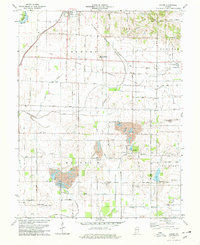
1978 Map of Epsom
USGS Topo · Published 1979About this map
Elnora and the northern reaches of Daviess County define this landscape during the late 1970s. The map illustrates a transitional rural economy where traditional agriculture meets intensive resource extraction, notably seen in the large Strip Mine operations north of Epsom. Transportation infrastructure is anchored by the Conrail and Chicago Milwaukee St Paul and Pacific rail lines, which cut through the northwestern townships near the White River. Local life is recorded through numerous small burial grounds such as Ketchem Cem and Humphries Cem, while community centers like the North Daviess Jr-Sr High Sch and the County Fairgrounds provide focal points for the surrounding townships of Elmore, Madison, and Bogard. The hydrology of the area, featuring Smothers Creek and Hanna Cr, is heavily managed through systems like Kane Ditch and Hays Ditch, reflecting the region's long history of land reclamation for farming.
Find a feature on this map
39 named features on this map. Tap any name to fly to it.
Don’t see what you’re looking for? This feature index may not catch every label — zoom into the map to look around manually.
Map Details
Editions of this 1978 Epsom Map
2 editions found
Other maps of this area

1943 · Lyons
USGS Topo · 1:24,000

1943 · Sandborn
USGS Topo · 1:24,000

1943 · Plainville
USGS Topo · 1:24,000

1943 · Epsom
USGS Topo · 1:24,000

1944 · Montgomery
USGS Topo · 1:24,000

1944 · Washington
USGS Topo · 1:24,000

1950 · Odon
USGS Topo · 1:24,000

1956 · Loogootee
USGS Topo · 1:24,000

1956 · Vincennes
USGS Topo · 1:250,000

1957 · Vincennes
USGS Topo · 1:250,000