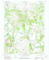
1958 Map of Sandy Hook
USGS Topo · Published 1981About this map
The confluence of the White River and the East Fork dominates this corner of Daviess County, where river bends have created a series of backwater features like Jackson Pond, Wonder Pond, and Horseshoe Pond. The landscape is a mix of agricultural bottomlands and industrial sites, notably marked by Strip Mines and a Strip Mine located near Rogers. This mid-century view, updated with aerial data from the 1970s, reveals a rural network anchored by family-named landmarks and local institutions.
Find a feature on this map
42 named features on this map. Tap any name to fly to it.
Don’t see what you’re looking for? This feature index may not catch every label — zoom into the map to look around manually.
Map Details
Editions of this 1958 Sandy Hook Map
Other maps of this area

1902 · Ditney
USGS Topo · 1:125,000

1903 · Velpen
USGS Topo · 1:62,500

1903 · Petersburg
USGS Topo · 1:62,500

1944 · Montgomery
USGS Topo · 1:24,000

1944 · Glendale
USGS Topo · 1:24,000

1944 · Washington
USGS Topo · 1:24,000

1944 · Monroe City
USGS Topo · 1:24,000

1944 · Wheatland
USGS Topo · 1:24,000

1945 · Sandy Hook
USGS Topo · 1:24,000

1956 · Vincennes
USGS Topo · 1:250,000