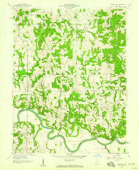
1958 Map of Glendale
USGS Topo · Published 1959About this map
The East Fork White River anchors the southern landscape of this Daviess County survey, winding through the townships of Jefferson, Harrison, and Reeve. This mid-century view shows a rural patchwork of small settlements and community landmarks, such as the Glendale State Fish and Game Preserve and the scattered hamlets of Glendale, Hudsonville, and Corning. Genealogy and local history researchers will find a significant distribution of pioneer-era burial sites and rural congregations, including Glencoe Cem, Ebenezer Cem, and the St Patricks Ch. The map captures a moment before significant modern development, where family-named features like Aikman Creek and Beckett still defined the local geography. Significant infrastructure of the era is noted by the Stewart Road Bridge, while the confluence of Mud Creek and the river illustrates the drainage patterns vital to the region's agricultural character.
Find a feature on this map
36 named features on this map. Tap any name to fly to it.
Don’t see what you’re looking for? This feature index may not catch every label — zoom into the map to look around manually.
Map Details
Editions of this 1958 Glendale Map
This is the sole edition of this map. No revisions or reprints were ever made.
Other maps of this area

1902 · Ditney
USGS Topo · 1:125,000

1903 · Velpen
USGS Topo · 1:62,500

1944 · Montgomery
USGS Topo · 1:24,000

1944 · Glendale
USGS Topo · 1:24,000

1944 · Washington
USGS Topo · 1:24,000

1945 · Sandy Hook
USGS Topo · 1:24,000

1946 · Jasper
USGS Topo · 1:24,000

1956 · Alfordsville
USGS Topo · 1:24,000

1956 · Loogootee
USGS Topo · 1:24,000

1956 · Vincennes
USGS Topo · 1:250,000