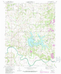
1974 Map of Glendale
USGS Topo · Published 1988About this map
Dogwood Lake serves as the centerpiece of this Southern Indiana landscape, surrounded by the extensive Glendale State Fish and Wildlife Area. The map reveals a rural structure defined by a strict grid of numeric roads, such as 400 South Road, punctuated by small settlements like Glendale and Hudsonville. The winding course of the White River and its East Fork carve the southern and western boundaries, where High Rock stands as a notable elevation above the riverbank.
Find a feature on this map
71 named features on this map. Tap any name to fly to it.
Don’t see what you’re looking for? This feature index may not catch every label — zoom into the map to look around manually.
Map Details
Editions of this 1974 Glendale Map
2 editions found
Other maps of this area

1902 · Ditney
USGS Topo · 1:125,000

1903 · Velpen
USGS Topo · 1:62,500

1944 · Montgomery
USGS Topo · 1:24,000

1944 · Glendale
USGS Topo · 1:24,000

1944 · Washington
USGS Topo · 1:24,000

1945 · Sandy Hook
USGS Topo · 1:24,000

1946 · Jasper
USGS Topo · 1:24,000

1956 · Alfordsville
USGS Topo · 1:24,000

1956 · Loogootee
USGS Topo · 1:24,000

1956 · Vincennes
USGS Topo · 1:250,000