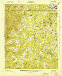
1942 Map of Epworth
USGS Topo · Published 1942About this map
Fightingtown Creek winds through this 1942 survey of the Georgia-Tennessee borderlands, connecting the rural communities of Epworth and McCaysville. The landscape is defined by the sharp divide between the Cherokee National Forest to the north and the Chattahoochee National Forest to the south. This era shows a well-established network of small rural institutions, from Hipp Sch and Mt Moriah Sch to churches like Bethel Ch and Damascus Ch. Local commerce is grounded in the valley floor at sites like Higdon Store, Patterson Mill, and Galloway Mill. Along the Ocoee River, the industrial presence of the Louisville and Nashville railroad serves the border towns of Copperhill and Fry, marking a transition from the agricultural highlands to the mineral-rich Tennessee Copper Basin.
Find a feature on this map
62 named features on this map. Tap any name to fly to it.
Don’t see what you’re looking for? This feature index may not catch every label — zoom into the map to look around manually.
Map Details
Editions of this 1942 Epworth Map
This is the sole edition of this map. No revisions or reprints were ever made.
Other maps of this area

1886 · Dalton
USGS Topo · 1:125,000

1886 · Cleveland
USGS Topo · 1:125,000

1888 · Ellijay
USGS Topo · 1:125,000

1892 · Cleveland
USGS Topo · 1:125,000

1892 · Ellijay
USGS Topo · 1:125,000

1892 · Dalton
USGS Topo · 1:125,000

1893 · Murphy
USGS Topo · 1:125,000

1895 · Cleveland
USGS Topo · 1:125,000

1897 · Dalton
USGS Topo · 1:125,000

1898 · Ellijay
USGS Topo · 1:125,000