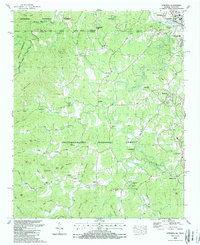
1988 Map of Epworth
USGS Topo · Published 1988About this map
Copperhill and McCaysville straddle the state line where the Ocoee River cuts through the mountains, marking a significant industrial and transport hub during the late 1980s. This survey, updated from earlier mid-century records, illustrates the complex topography of the Chattahoochee National Forest and Cherokee National Forest. The landscape is defined by its water-powered history and tight-knit mountain communities, visible in landmarks such as Patterson Mill and Galloway Mill. Family and community roots are deeply embedded here, evidenced by numerous rural houses of worship like Shady Grove Ch and Mt Harmony Ch. The transition from the high ridges of Tumbling Lead to the settled valleys near Epworth shows how geography dictated the placement of early roads like Pack Creek Road and local centers like West Fannin Sch.
Find a feature on this map
89 named features on this map. Tap any name to fly to it.
Don’t see what you’re looking for? This feature index may not catch every label — zoom into the map to look around manually.
Map Details
Editions of this 1988 Epworth Map
This is the sole edition of this map. No revisions or reprints were ever made.
Other maps of this area

1886 · Dalton
USGS Topo · 1:125,000

1886 · Cleveland
USGS Topo · 1:125,000

1888 · Ellijay
USGS Topo · 1:125,000

1892 · Cleveland
USGS Topo · 1:125,000

1892 · Ellijay
USGS Topo · 1:125,000

1892 · Dalton
USGS Topo · 1:125,000

1893 · Murphy
USGS Topo · 1:125,000

1895 · Cleveland
USGS Topo · 1:125,000

1897 · Dalton
USGS Topo · 1:125,000

1898 · Ellijay
USGS Topo · 1:125,000