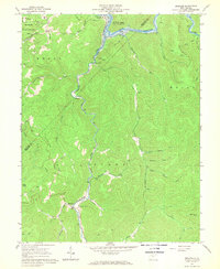
1967 Map of Erbacon
USGS Topo · Published 1968About this map
Centralia sits at the northern edge of this rugged Appalachian landscape, where the Elk River begins to broaden into the Sutton Lake backwaters. The valley floor is dominated by the winding path of the Baltimore and Ohio railroad, which tracks alongside Laurel Creek through the settlements of Prestonia and Erbacon. This corridor served as a vital transport link through the steep ridges of the Glade and Holly regions, connecting isolated communities and timber resources.
Find a feature on this map
44 named features on this map. Tap any name to fly to it.
Don’t see what you’re looking for? This feature index may not catch every label — zoom into the map to look around manually.
Map Details
Editions of this 1967 Erbacon Map
2 editions found
Other maps of this area

1889 · Nicholas
USGS Topo · 1:125,000

1891 · Nicholas
USGS Topo · 1:125,000

1891 · Huntersville
USGS Topo · 1:125,000

1893 · Buckhannon
USGS Topo · 1:125,000

1893 · Sutton
USGS Topo · 1:125,000

1894 · Huntersville
USGS Topo · 1:125,000

1896 · Buckhannon
USGS Topo · 1:125,000

1897 · Buckhannon
USGS Topo · 1:125,000

1901 · Nicholas
USGS Topo · 1:125,000

1908 · Sutton
USGS Topo · 1:48,000