
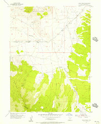
1971 Map of Erickson Knoll
USGS Topo · Published 1974About this map
The Sheeprock Mountains dominate this high-altitude landscape on the border of Tooele Co and Juab Co, where historical mining activity is etched into the steep drainages. In the early 1970s, the area remained a landscape of remote resource extraction and high-country ranching, centered around peaks like Black Crook Peak and the namesake Erickson Knoll. Small-scale mining operations and prospects are scattered through the eastern canyons, including the Flying Dutchman Mine, Utah Mine, and Copper Jack Mine, reflecting a persistent search for minerals along the mountain flanks. Isolated outposts such as Wright Ranch, Ekker Ranch, and Black Ranch mark the few points of habitation, connected by a network of primitive trails and jeep roads. Much of the terrain is protected within the Wasatch National Forest, preserving groves like Upper Pine Grove and Lower Pine Grove amidst the complex system of washes, including Erickson Creek and Oak Brush Wash.
Find a feature on this map
45 named features on this map. Tap any name to fly to it.
Don’t see what you’re looking for? This feature index may not catch every label — zoom into the map to look around manually.
Map Details
Editions of this 1971 Erickson Knoll Map
This is the sole edition of this map. No revisions or reprints were ever made.
Other maps of this area

1885 · Sevier Desert
USGS Topo · 1:250,000

1885 · Tooele Valley
USGS Topo · 1:250,000

1953 · Tooele
USGS Topo · 1:250,000

1953 · Delta
USGS Topo · 1:250,000
1955 · Indian Peaks
USGS Topo · 1:24,000
1955 · Indian Springs
USGS Topo · 1:24,000

1955 · Tooele
USGS Topo · 1:250,000

1958 · Delta
USGS Topo · 1:250,000

1962 · Delta
USGS Topo · 1:250,000
1963 · Dutch Peak
USGS Topo · 1:24,000